
vehicle gps: maps for navigator
sat nav for car: windows ce
navigator for cars: warehouse in europe
gps truck navigation europe 7 inch: gps navigation bluetooth
gps coche: gps navigation for car
gps car navigation: car gps
gps car europe 2020: gps truck navigation europe 2020
car gps: europe truck sunshade
Special Features: bluetooth,FM Transmitter,MP3/MP4 Players,Touch Screen
Screen Resolution: 800x480
Origin: Mainland China
Model: XGODY J727F
Memory Size: 256MB RAM 8GB Internal Memory
GPS type: Vehicle GPS Units & Equipment
GPS Navigator with TF Card: No
GPS Module: High Sensitive GPS Receiver
Display Screen: 7'' Capacitive screen
Certification: CE
Brand Name: XGODY
7 inch gps navigation: navigator car
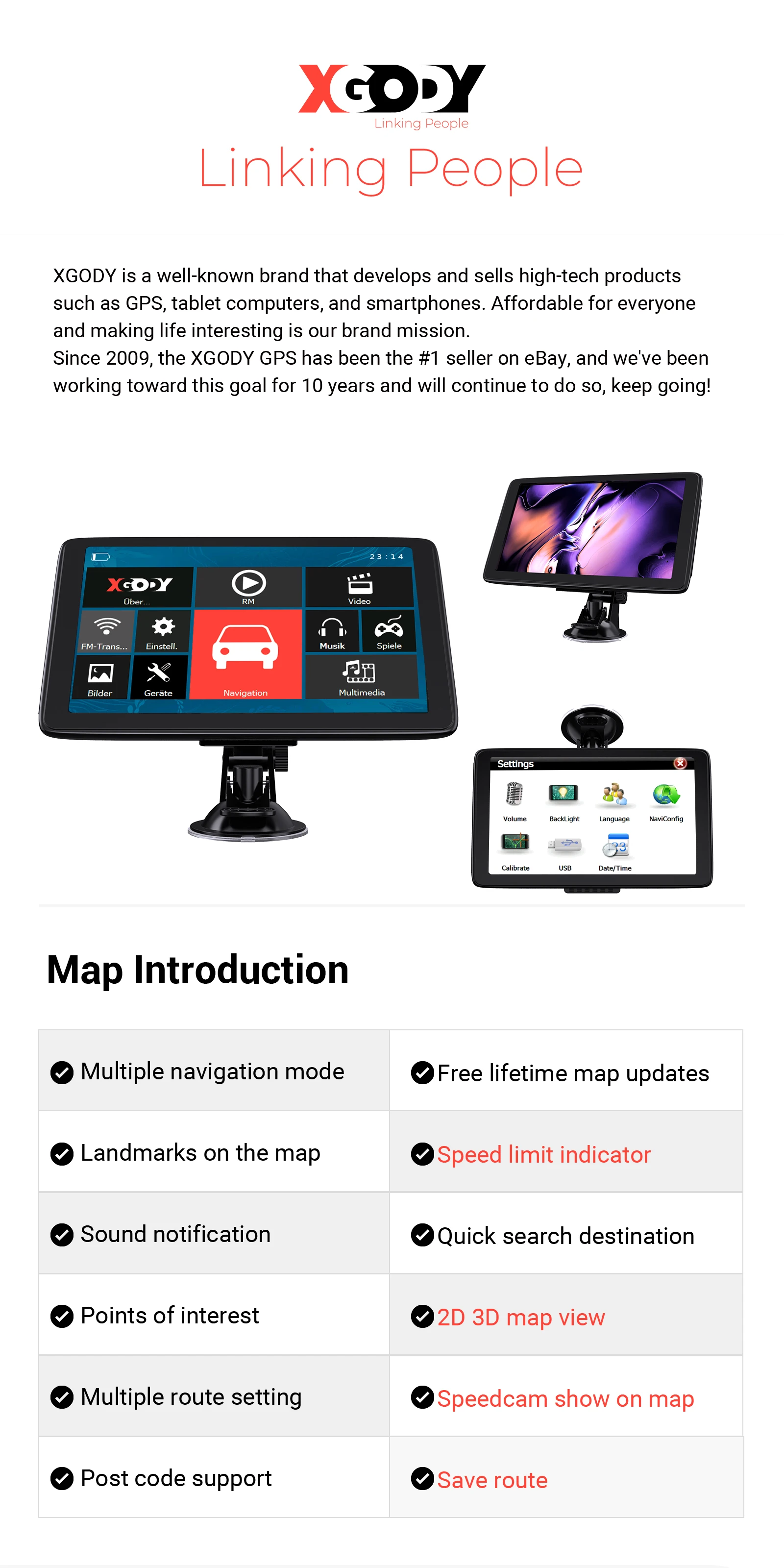
Specification:
---CPU:Cortex-A9-MSB2531
---GPS Module:High Sensitive GPS Receiver
---Memory Size:256MB RAM – 8GB Internal
Memory
---Display Screen:7'' Capacitive screen,Resolution 800*480
---USB:USB Client 2.0, MINI USB 5PIN socket
---SD Slot:Micro SD socket, MAX Micro SD card up to 32GB
---Audio:A: Built-in 1W/ 8 ohm B: Stereo track: 0.25W/CHANEL, single track 8 ohm/1W
---FM:FM transmitter (76.0MHz -108MHz) Transfer the GPS sound to Car,not FM Radio
---Battery:Built–in Li-ion Rechargeable 2100mAh
---Working Time:About 1 hour
---Charging Time:2-3 hours,Sometimes can only -charge to 99%
---Charging Socket:12V DC socket
---Car Charger:8-36V/2A
---Temperature Range:Operation temperature: -10 °C to 60 °C Saving temperature:0 °C to 60 °C
---Size:184mm x110mm x28mm
---Navigation Storage:More than 49 countries maps, included Asia and European: United Kingdom, Australia, NewZealand , Albania, Austria, Belarus,Bosnia & Herzegovina, Belgium, Bulgaria, Croatia, Cyprus, Czech, Denmark, Estonia, Finland, France, Macedonaa FYRM, Germany, Gibralt
---Video Playing Software: Support ASF,AVI,WMV,MPG,DAT,MPEG,3GP
---Audio Playing Software:Support WMA9, MP3 and WAV format
---Photo Format:Support JPG, GIF, BMP ,PNG format
---System Languages:English,Portuguese,Magyar,Italiano,Français,Español,Deutsch, Nederlands,Dansk,Svenska,Norsk,Ελληνικά,ру́сский,čeština, Suomi,Polski,Slovenia,Turkish,Roman,Arabic,Thai,Srpski, Slovenian, עִבְרִית,Lietuvių,Eesti keel,български,Persian, Yкраїнська,Indonesia
Map: default map
-- Europe (2022) : Albania, Andorra, Austria, Belarus, Belgium, Bosnia, Britain, Bulgaria, Croatia, Cyprus, Czech, Denmark, Estonia, Finland, France, Germany, Gibraltar, Greece, Hungary, Iceland, Ireland, Italy, Kosovo, Latvia, Liechtenstein, Lithuania, Luxembourg, Macedonia, Malta, Moldova, Montenegro, Monaco, Netherland, Norway, Poland, Portugal, Romania, Russia, SAN Marino, Serbia, Slovakia, Slovenia, Spain, Sweden, Switzerland, Turkey, Ukraine, Vatican
-- North America (2022): Canada, Mexico, United States
-- South America (2019) :Argentina, Bolivia, Brazil, Chile, Colombia, Ecuador, French Guiana, Paraguay, Peru, Uruguay, Venezuela
-- Central America (2019): Bahamas, Cayman, Costa Rica, Dominica, Guadeloupe, Guatemala, Martinique, Nicaragua, Panama
-- Asia (2021): Azerbaijan, Brunei, Georgia, Hong Kong, India, Indonesia, Kazakhstan, Macao, Malaysia, Philippines, Singapore, Sri Lanka, Taiwan, Thailand, Vietnam
-- Middle East (2020) : Bahrain, Iraq, Israel, Jordan, Kuwait, Lebanon, Oman, Qatar, Saudi Arabia, United Arab Emirates, Yemen
-- Australia (2021) : Australia, New Zealand
-- Africa (2020) : Algeria, Angola, Benin, Botswana, Burkina Faso, Burundi, Cameroon, Cape Verde, Central African Republic, Chad, Comoros, Democratic Republic of Congo, Djibouti, Egypt, Equatorial Guinea, Eritrea, Ethiopia, French Guiana, Gabon, Gambia, Ghana, Guinea, Guinea-Bissau, Kenya, Lesotho, Liberia, Libya, Madagascar, Malawi, Mali, Mauritania, Mauritius, Mayotte, Morocco, Mozambique, Namibia, Niger, Nigeria, Republic of Congo, Reunion, Rwanda, Senegal, Seychelles, Sierra Leone, Somalia, South Africa, South Sudan, Sudan, Swaziland, Tanzania, Togo, Tunisia, Uganda, Zambia, Zimbabwe
Option: Russia Navitel Map
Russia (2017), Pakistan (2019)
(Russia buyer need this map please leave message on the order,or we will download default map)
Common problems and solutions
Q: The GPS has no sounds.
A: Please turn off the FM.
Q: Why it can't receive the satellite signal?
A: Satellites broadcast signals to enable GPS receive the information of the Earth's surface to locate and synchronized time. The most common factor that interferes with a GPS signal is "Urban Canyon" (The high rise building and skyscrapers block and weak signal receiving), weather (bad weather will Weaken the GPS signal) and car protect film. So if you cannot receive signal, please go to an open area to receive signal.
Q: When I click Navigation Icon, it has nothing happen, can’t enter the map?
A: Please set the Navi Path:
Navi Path—Navigation Path—Resident Flash, set step by step, until it shows “.exe”, if still can’t set, please contact us!
Q: The battery can’t charge and run the GPS.
A: The battery in this GPS are not designed to last a long time like a mobile phone. Considering the full battery charge as more for emergency use. battery just assistant the GPS normal working. Plug in your car charger while driving will be better. Please connect your car power when running the GPS.